


Le puy en vêlât - saint privât d’allier

papyveto
User
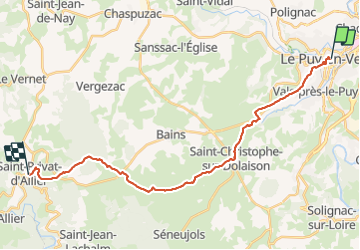

Length
25 km

Max alt
1214 m

Uphill gradient
661 m
Km-Effort
33 km

Min alt
640 m

Downhill gradient
470 m
Boucle
No
Creation date :
2021-10-17 06:57:43.0
Updated on :
2021-10-17 14:47:29.509
7h42
Difficulty : Very difficult

FREE GPS app for hiking
 SityTrail
IGN / Geographical institutes
SityTrail Plus
The world is yours!
About
Trail Walking of 25 km to be discovered at Auvergne-Rhône-Alpes, Haute-Loire, Le Puy-en-Velay. This trail is proposed by papyveto.
Positioning
Country:
France
Region :
Auvergne-Rhône-Alpes
Department/Province :
Haute-Loire
Municipality :
Le Puy-en-Velay
Location:
Unknown
Start:(Dec)
Start:(UTM)
569775 ; 4988435 (31T) N.
Comments